Following significant landslides in 2020, a bespoke operational strategy has been implemented to facilitate the safe use of the A83 corridor at the Rest and Be Thankful. The questions and answers below explain more about the Rest and Be Thankful.
Where exactly is the Rest & Be Thankful located? The Rest and Be Thankful is located on the A83 in Argyll and Bute, between Arrochar and Inveraray. The stretch of road is over 240 metres above sea level and passes through Glen Croe. The current A83 was constructed in the 1930s and is cut into the side of the hill. It replaced the historic Old Military Road which runs along the valley floor with a steep hairpin section at the north end of the Glen.
How did the Rest and Be Thankful get its name The road climbs steeply out of Glen Croe and traditionally, travellers would stop at the top to ‘Rest and Be Thankful’. The route is still popular with cyclists as well as being a lifeline route for residents in Argyll.
How are landslides triggered in the area? Landslides are triggered by heavy rainfall or snow melt and normally occur after prolonged wet periods. This causes over-saturation of the ground, which can lead to debris such as mud and rocks sliding down the hill.
What is the history of landslides at the Rest and Be Thankful?
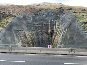
There is a history of landslides ranging from very minor slips with no impact on the road to significant events. In August and September 2020, a combined total of 16,000 tonnes of material was displaced from the hillside.
What has been done to reduce the impact of landslides?
The Old Military Road, a single track road which runs alongside the A83, is used under convoy control as a local diversion when there’s a landslide or concerns about hillside conditions above the A83.
To prevent debris from reaching the A83, several measures have been taken, such as installing debris fences, roadside catch-pits and improving drainage. Additionally, a temporary bund (embankment) has been set up near the Old Military Road below the area affected by the 2020 events, to make the local diversion route more resilient.
Rest and Be Thankful channel 3b catchpit
How is the landslide risk being monitored? The A83 is monitored daily to keep road users safe. This includes checking detailed weather forecasts, estimating saturation levels, monitoring slopes using timelapse photography and inspections by geotechnical engineers to ensure the road operates safely.
What traffic managements arrangements are in place on the A83? The nature of the hillside is such that this section of the A83 requires more maintenance work than other locations. Temporary traffic lights may therefore be in place to allow works to be carried out.Ensuring road users’ safety is the top priority. BEAR Scotland and Transport Scotland monitor daily weather forecasts and live information from the site. When necessary, traffic lights and a convoy system may be used on the A83. During the most severe weather, the Old Military Road can also serve as a local diversion route under convoy control. Read more here about the range of traffic management responses that are being used.
Is there a diversion route if the A83 is impassable? The Old Military Road local diversion route is used under convoy control. In exceptional circumstances, if it’s unsafe to use the Old Military Road, traffic will be diverted onto the A82/A85/A819.
How long are the diversion routes? The Old Military Road local diversion is the same distance as the route on the A83. However, as it is a single track road, it’s operated under a convoy system for safety. Travelling along this route takes approximately 15 to 20 minutes, compared to three to six minutes on the A83. At very busy times, occasionally the delays can be longer.
In rare circumstances, when the longer diversion route is necessary, it can add up to 60 miles to your journey. However, for most trips, the extension is around 30 miles, depending on your starting and ending points.
Why is the Rest and Be Thankful particularly impacted by bad weather? The soil type, steepness of the hillsides and the A83’s location, along with Argyll’s climate, make this area susceptible to landslides, which can affect the trunk road’s operation.
Are works currently underway at the Rest and Be Thankful? You can find more information any of our works in the Latest News section of our website.
What should I consider when planning a journey via the Rest and Be Thankful?
While full closures of the A83 are uncommon, road users are advised to plan their trips using the latest travel advice provided on the Traffic Scotland website, specifically the A83 Rest and Be Thankful section. This resource informs you about daily traffic management arrangements and provides an estimate of journey times through the Glen.
What’s the best way to get accurate, up‑to‑date information about road conditions? We recommend checking Traffic Scotland website or app before setting off, rather than relying solely on satnavs or other map apps. Satnavs and map apps don’t always show up‑to‑date incidents, roadworks, closures, or weather‑related disruptions. Traffic Scotland provides real‑time information for Scotland’s trunk roads, helping you choose the safest and most reliable route for your journey.Check live conditions on the Traffic Scotland website.